
Land Surveying and Land Management - Landscape Morphology connects the shape of the land to how we measure, manage, and plan for it, using a toolkit that spans traditional total stations to drones, LiDAR, and GIS to turn terrain into actionable maps and decisions. Proper governance and licensure underpin professional practice, ensuring accuracy, ethics, and public safety in land-management projects.

Why regulatory oversight matters for morphology-driven work
Because land surveying intersects property boundaries, environmental planning, and public safety, licensure and code-compliant practice matter. State licensing boards establish minimum competencies, ethical expectations, and continuing-education requirements that translate into reliable measurements, defensible plats, and defensible decisions about drainage, erosion control, and development. For context on how licensing governs land surveyors, see the Engineering and Land Surveying Board (Iowa) – licensing, rules, and resources.
Foundations: definitions and role of geodetic control
Landscape morphology relies on accurate reference frameworks. The NOAA National Geodetic Survey – land surveying overview explains how geodetic control, bench marks, and survey data underpin mapping accuracy, scale, and landscape-analysis workflows. This baseline helps ensure that topographic models used for drainage, soil assessments, and boundary determinations are consistent across projects.

Educational pathways that underpin morphology practice
Educational programs provide essential credentials for professionals working on morphology-focused projects. For example, College of the Canyons – Land Surveying program illustrates formal curricula, degrees or certificates, and licensure context that support practitioners contributing to landscape morphology workflows. Similarly, Dunwoody College of Technology – Land Surveying certificate highlights accelerated or hands-on pathways into surveying careers. Northwest Vista College – Land Surveying Technician certificate serves as an entry-point for field-data collection and boundary-work skills that feed into more advanced morphologic analyses.
Practical survey methods for mapping morphology
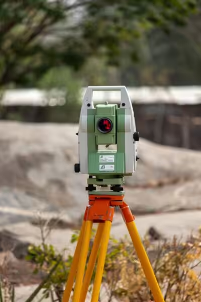
Field methods used to map morphology combine classic and modern techniques. GNSS/RTK and total-station control provide precise ground points and boundary data; terrestrial LiDAR captures complex built environments and cliff faces in high detail; UAV photogrammetry (SfM) yields high-resolution orthomosaics and dense point clouds; airborne LiDAR covers large areas, especially when vegetation hides the ground. Survey firms tailor these approaches to scale, budget, and regulatory context, then post-process to produce contours, hillshade, and slope maps for land-management decisions.
Drone surveys, orthomosaics, and point clouds in morphology work
Drone-based morphology mapping has become routine. Structure-from-motion techniques deliver orthomosaics and dense point clouds; LiDAR payloads on drones can penetrate canopy to reveal bare-earth surfaces, often with superior vertical accuracy. These outputs support hydrology, erosion analyses, and site-planning decisions. When selecting a survey partner, ask for deliverables such as orthomosaics, DSM/DTM, and a documented accuracy assessment to validate morphology models.
GIS as the integrative platform
GIS overlays cadastral boundaries, land-use zoning, soils, and hydrology on DTMs to answer practical questions about fence placement, drainage, and subdivision potential. Public agencies and private surveyors rely on GIS to generate parcel maps, site-suitability analyses, and erosion-risk layers that inform permitting and project feasibility.
Common applications: from cadastral surveys to erosion control
Landscape morphology informs a range of services, including property boundary surveys and plats, topographical surveys for design, hydrologic and erosion modeling, and site-planning for conservation or development. Deliverables—such as plats, contours, DTMs/DSMs, and feature layers—should be specified upfront to avoid scope creep. Pricing and cadence are driven by terrain complexity, access, and required accuracy.
Choosing between photogrammetry and LiDAR for morphology
Photogrammetry (SfM) excels for high-resolution color orthophotos in open terrain and cost-sensitive projects, while LiDAR provides robust bare-earth models under vegetation and strong vertical accuracy. A hybrid workflow—LiDAR for the ground model and photogrammetry for texture—often yields the most robust morphology datasets for design, hydrology, and erosion analyses.
Costs, deliverables, and typical survey services
Deliverables vary by service type: boundary surveys yield a plat with marked corners; topographical surveys provide contours, spot elevations, and feature layers; measured-building surveys capture as-built conditions and elevations. Cost drivers include site accessibility, vertical-accuracy requirements, project area, and whether specialized sensors or ground control are needed. When budgeting, reference common queries such as “land survey cost near me” to anticipate regional variation and project-specific complexity.
Best practices for accurate landscape morphology mapping
Key practices include establishing a geodetic control framework and documenting the reference system used, employing ground control points for UAV validation, carefully classifying point clouds to separate bare earth from vegetation or built features, and reporting uncertainty (RMSE) clearly to support floodplain and grading decisions. For governance context, see the licensing and regulatory references above to understand how standards translate into field procedures.
Common mistakes and how to avoid them
Avoid conflating DSM with DTM, poor control-point placement, and inadequate point-classification. Require explicit deliverables (DTM vs DSM) and survey-grade GNSS control for legal work. Always request method documentation and accuracy statistics from morphology-focused projects, and verify that outputs align with regulatory expectations and project requirements.
Landscape morphology for planning, resilience, and risk reduction
Mapping morphology supports resilience by identifying flood pathways, slope stability risks, and soil-loss areas. Integrating morphological metrics with land-use planning helps locate infrastructure and conservation measures to minimize hazards and maximize ecosystem services. This context is particularly relevant for projects near watersheds or in flood-prone zones where accurate terrain models influence drainage design and mitigation strategies.
How to find the right surveyor for morphology work
Identify local surveyors who produce DTMs and orthophotos, and who employ UAVs or LiDAR. Review sample deliverables, accuracy metrics, references for similar morphology-focused projects, licensure status, and insurance coverage. Consider asking candidates about workflow timing, data formats, and how outputs will support your land-management goals.
Frequently asked technical questions
Difference between DSM and DTM
A DSM includes surface objects such as trees and buildings; a DTM represents the bare ground used for hydrology and earthworks. For drainage and erosion analysis, a DTM is typically required.
Topographical vs. boundary surveys
A boundary survey establishes legal property lines; a topographical survey provides elevations and site features for design. Many projects benefit from both, and some surveyors offer a combined package.
Next steps for applying landscape morphology to your project
Clarify your decision-driving questions—legal boundaries, grading, drainage, or habitat restoration—and specify deliverables (DTM, DSM, orthomosaic, point cloud). Request accuracy metrics and confirm how outputs support your land-management goals. If you’re seeking formal references, consult the internal governance pages linked above to understand the regulatory expectations that shape morphology work.
We’d love to hear about your experiences with landscape morphology in land surveying. Have you used drone-based morphology mapping for a project, or worked with a boundary survey that relied on terrain models? Share your stories or questions in the comments to help others plan more effectively.
For regulatory context on professional practice, see the Engineering and Land Surveying Board (Iowa) – licensing, rules, and resources.
The basic framework of land surveying relies on precise reference systems and geodetic control; the NOAA National Geodetic Survey – land surveying overview explains these foundations and their role in mapping accuracy and landscape morphology studies.
Licensure requirements and ethical standards underpin professional practice; see Maryland Law and Regulations – Land Surveyors for a state example of governance that influences field operations and client obligations.
Educational programs exemplifying formal training in surveying include College of the Canyons – Land Surveying program, Dunwoody College of Technology – Land Surveying certificate program, and Northwest Vista College – Land Surveying Technician certificate. These programs illustrate credential pathways that support morphology-focused work in the field.
For broader context on how government, educational institutions, and professional bodies shape surveying standards, see the following internal resources: Land Surveying and Landscape Morphology (Architecture Adrenaline) and related articles in Architecture Adrenaline’s Outdoor Living and Landscaping sections.
```
Every Urban Planning Concept Explained in 9 Minutes:
As we conclude our exploration of land surveying and land management through the lens of landscape morphology, it’s clear that understanding the intricacies of our land can make a significant difference in how we utilize it effectively and sustainably. By delving into the various shapes and forms of the landscape, we not only enhance our planning strategies but also gain a deeper appreciation for the natural world around us. So whether you’re a professional in the field or just someone who enjoys learning about the world we inhabit, keep in mind that every contour and curve tells a story waiting to be discovered.
Stay Connected and Explore More!
If you found this journey into land surveying and landscape morphology as fascinating as I do, I encourage you to stay connected! There’s always more to learn, and I love sharing insights and updates. You can catch me on social media where I regularly post about these topics, so check out my Instagram for some visual inspiration and updates. Let’s continue this conversation and explore the beauty of our landscapes together!
